| |
|||||
|
RTC integral to oil spill response | ||||
|
August 10, 2006 |
|||||
|
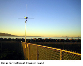
The four-day exercise, "Safe Seas 2006," involved almost 300 people from all agencies charged with responding to oil spills including the United States Coast Guard, U.S. Department of the Interior and the California Office of Spill Prevention and Response. The exercise scenario involved the hypothetical collision of a cargo ship with a tugboat hauling an oil barge that spills 350,000 gallons of oil with the potential to spoil the coastal areas from Bodega Bay to south of Monterey Bay. RTC partnered with other Northern California universities to install and monitor the network of high-frequency radar instruments. Operating like the Doppler radar system that determines the density of precipitation, the sensors record and transmit the direction and movement of ocean surface currents. This real-time surface current mapping is immediately accessible on the Web to responders who deploy booms and dispatch decontamination crews. The high-frequency radar, which operates at 42 megaherz and 12 megaherz, can also help in search and rescue missions and habitat maintenance and restoration. Sensors deployed in the vicinity of San Francisco are located in the Bay at RTC, near the Berkeley Marina, Crissy Field and at Treasure Island. Coastal sensors are near Bolinas, Fort Funston and Montara. The Northern and Central California Ocean Observing System and a sister system for Southern California are part of the Coastal Ocean Currents Monitoring Program (COCMP) and are funded through the California Coast Conservancy with State funding. Toby Garfield, professor of oceanography, acting director of RTC and coordinator of the Northern California COCMP, said the monitoring equipment was funded primarily by clean water bond propositions passed by California voters in 2002. "The California voters made a very good investment in the health and protection of our coastline," Garfield said. "A significant oil spill would devastate San Francisco Bay Area wildlife and habitat as well as our tourism and fishing industries. This monitoring program gives us a fighting chance to effectively respond to a spill and to prevent the kinds of damage seen in Alaska." In addition to RTC, the universities involved in the Northern and Central California Ocean Observing System are Humboldt State University; University of California, Davis, Bodega Bay Marine Lab; University of California, Santa Cruz; Naval Post Graduate School in Monterey; and California Polytechnic San Louis Obispo. More information about the COCMP, including the real-time information about San Francisco Bay and coastal waters can be found at the COCMP Web site.
|
|||||
 |
1600 Holloway Avenue, San Francisco, CA 94132 (415) 338-1111 |

 Oceanographers
at SF State's Romberg Tiburon Center for Environmental Studies (RTC)
played a key role in the National Oceanic and Atmospheric
Administration's (NOAA) full-scale oil spill simulation along the
coast of Northern California during the second week in August. Monitoring
sensors placed throughout the coastal and bayside areas in the Gulf
of the Farallones and Monterey Bay National Marine Sanctuaries, researchers
studied the currents and predicted what areas would suffer contamination.
The new technology was designed to expedite cleanup efforts and lessen
the effects of spill contamination on beaches and wildlife habitat.
Oceanographers
at SF State's Romberg Tiburon Center for Environmental Studies (RTC)
played a key role in the National Oceanic and Atmospheric
Administration's (NOAA) full-scale oil spill simulation along the
coast of Northern California during the second week in August. Monitoring
sensors placed throughout the coastal and bayside areas in the Gulf
of the Farallones and Monterey Bay National Marine Sanctuaries, researchers
studied the currents and predicted what areas would suffer contamination.
The new technology was designed to expedite cleanup efforts and lessen
the effects of spill contamination on beaches and wildlife habitat.