Geographer works with local people, technology to protect marine life
Oct. 4, 2011 -- In the Gulf of Thailand, where Associate Professor of Geography Ellen Hines conducts her field work, fishermen, scientists and policymakers know very little about the vulnerable marine life that lives locally.
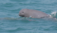
An Irrawaddy dolphin spotted in Trat Province in the eastern Gulf of Thailand. Credit: Somchai Mananunsap
"If you don't know how many animals there are or where they prefer to live, it's difficult to conserve and manage those populations," said Hines. "You don't know what's at stake."
Hines has studied dolphins, whales, porpoises and unusual sea creatures such as dugongs (sea cows) off the coast of Thailand for the last twelve years. She uses her expertise in field surveys and technologies such as geographic information systems (GIS) to estimate the number of marine mammals in specific populations.
Her latest project, in the eastern Gulf of Thailand, focuses on a blunt-nosed animal called the Irrawaddy dolphin. The species is believed to be threatened by accidental capture -- known as bycatch -- in commercial fishing nets and by coastal development. "When we began our work here, fishermen told us they had seen them but no one knew how many," Hines said.
Hines' fieldwork thrives on local connections. She collaborates with a dozen researchers, the majority of whom are natives of Thailand. "The goal is to share repeatable and practical methods that can be used by local scientists to survey these little known animals," Hines said.
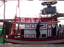
A local fishing boat that Hines and her team use to conduct boat surveys of marine mammals. Credit: Ellen Hines
Hines and her team conduct surveys using local fishing boats. For each survey, they sail a randomly generated route across the eastern Gulf of Thailand, repeating the route 3-4 times. Along the way, a team of observers continuously scans the horizon with the naked eye, and with binoculars, recording the number of animals seen per kilometer and estimating the exact angle of the sighting and the distance from the boat. The data is captured on GPS devices and is used to calculate statistically viable estimates of the total number of animals in the local population.
"The good news is that we are seeing more animals than we expected," said Hines. The surveys conducted in 2008 and 2009 suggest there could be a population of about 1,200 Irrawaddy dolphins in the area. In January, Hines will return to Thailand to collect the third and final wave of data.
The results will inform local and national conservation management efforts. Hines and her graduate students will also use the data for habitat modeling. Using GIS database and mapping technology, they will map dolphin sightings against such variables as sea surface temperature and salinity.
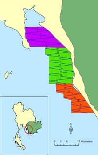
Map of the eastern Gulf of Thailand, showing an example of the zig-zag route taken by Hines and her team during their boat surveys. Inset shows Thailand in yellow.
As a geographer, Hines' research in Thailand also explores the interaction between humans and endangered populations. Her Thai colleagues have interviewed residents about their fishing practices and attitudes toward conservation. And during each season of boat surveys, Hines and her team are increasingly invited to give lectures to village councils, schools and community organizations about the need to protect the sea life in their province. "We inform people about the precious species in their waters and warn them about the dangers of pollution and bycatch," Hines said.
At SF State, Hines mentors six graduate students who are using surveys and GIS techniques to study animals such as elephant seals, bottlenose dolphins and manatees.
Geography graduate student Andrea Dransfield applied to SF State so that she could work under Hines' supervision. Working with the Point Reyes Bird Observatory and other agencies, Dransfield took part in a week-long boat survey of marine mammals in the Gulf of the Farallones National Marine Sanctuary this summer.
"I'm using GIS to overlay maps of the humpback whale sightings with maps of water temperature, salinity, topography of the ocean floor and primary productivity," said Dransfield, who will present her findings at three professional conferences this semester. "The idea is to identify habitat hotspots and make sure these don't coincide with shipping lanes. It's rewarding to know my work will make a difference."
For more information about Hines' work on marine and coastal conservation, visit http://gis.sfsu.edu/coastal/default.htm
Visit the Golden Date LIDAR Project website for more information about an effort led by Hines to provide high resolution topographical data about the San Francisco and Marin County peninsulas as part of the United States Geological Survey's National Map.
-- Elaine Bible
Share this story: