Geography goes high-tech with new master's program
March
16, 2010 -- When
Professor Ellen Hines maps the habitats of threatened dolphins off the
coast of Thailand, she uses geographical information systems -- sophisticated
database technology -- to link the distribution of dolphin populations
to such water properties as depth, salinity and how cloudy or opaque
the water is.
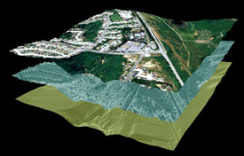
An image of the San Bruno area, generated with geographical information system software, using data from aerial photography (top layer) and LiDAR, laser technology used to measure topography (lower layers). The middle layer shows vegetation and buildings and the bottom layer represents the bare ground surface.
"The suite of tools we use in geographic information science can be used to model any data which has a spatial element to it, which covers just about everything," said Hines, associate professor of geography and human environmental studies. "There is very little that you can't map."
Hines is an expert in geographic information science (GIScience), an emerging field of study that combines aspects of geography, cartography and computing. It encompasses the development and use of geographic information systems, remote sensing, global positioning systems (GPS) and spatial statistics. To meet the growing demand for highly-skilled analysts capable of working with these tools, SF State has launched a new Master of Science in geographic information science, which is accepting applications for fall 2010.
Hines' latest project employs another technique in the GIScience toolkit -- LiDAR, a remote sensing technology that involves laser pulses emitted from an aircraft to measure topography. In a joint project with the United States Geological Survey (USGS), Hines will collect and process high resolution data on the San Francisco and Marin Country peninsulas, a more than 800-square mile area that includes Point Reyes National Seashore and the Golden Gate National Recreation Area.
So far, Hines has more than 30 local agencies interested in using the data. "The data will tell us about changes in land use, how climate change is affecting the Bay Area, what is happening to the buffer between land and sea where wetlands are being restored, as well as providing a picture of the urban areas that could be useful for urban planning and architecture," Hines said.
Hines' study is funded by the American Recovery and Reinvestment Act. The data will feed into a nationwide project called The National Map, an effort led by USGS to provide a detailed set of maps and data about the United States, which anyone can download at no cost.
Hines, along with others from the Department of Geography and Human Environmental Studies, will teach courses in the new master's program in GIScience. Applicants interested in applying to the program must apply by April 1.
More information can be found at: http://bss.sfsu.edu/geog/msgis.htm
-- Elaine Bible
Share this story: